Contents
Index
Write ESRI Shape File
This option will points to an ESRI format shape file in type 11 PointZ format.
An associated dbf file will be generated for the the following attributes for each point
Number, Type, Name, Code, Remark.
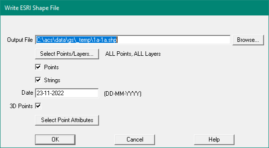
Select Points/Layers
This opens the Select Dialog to allow selection of points by layer and other parameters
Points
Tick this box to export the Points.
Strings
Tick this box to export the Strings
Date
The data is added to the dbf file which contains the Points/Strings attribute data.
Nine files may be created:
- Jobname_Points.dbf - Point attribute data
- Jobname_Points.shp - Point co-ords data
- Jobname_Points.shx - Index for the Point.shp file
- Jobname_Points.prj - Projection for the Point.shp file
- Jobname_Polygons.dbf - Polygons attribute data
- Jobname_Polygons.shp - Polygons coords data
- Jobname_Polygons.shx - Index for the Polygons.shp file
- Jobname_Polygons.prj - projection for the Polygons.shp file
- Jobname_Polylines.dbf - Polylines attribute data
- Jobname_Polylines.shp - Polylines coords data
- Jobname_Polylines.shx - Index for the Polylines.shp file
- Jobname_Polylines.prj - Projection for the Polylines.shp file
Un-closed strings are exported to the 'Polyline' file and Closed strings (Lots) to 'Polygon' file.
String Attributes
String Values Exported
- Layer Name
- String Name
- Plan Name
- String Type - "Lot","Traverse","Unannot","Road", ..
- String length in metres
- Discon/Breakline set to 1 if discon
- Start Chainage of the string
- Line Style
Point Values Exported
The following attributes are exported for each point.
- Point Number
- Easting
- Northing
- Height (if present)
- Code
- Layer Name
- Remark
- Name
- Point type - "Point","Station","Control","interpolated","Reference Mark","Bench Mark"
- Symbol Name (if not ByLayer)
- Attribute 1-5 (if present)
Point Attributes Exported
Each point may have one or more attribute values.
The Select Attributes Dialog dialog displays a list of all the attributes used by all the Chosen points
and allows you to choose which ones should exported.
Projection File
For each of the Entities exported (Points, Polygons, Polylines - the program will also write
a projection file. This will contain the Datum and projection for the data.
Notes: If the Datum/projection file contains a value in the 'Description' (column Q, or column 17)
It will be appended to the Datum name.
If the datum name is "GDA_1994", and the 'description' is "Perth Coastal Grid 1994"
the datum field in the projection file will be
"GDA_1994_Perth_Coastal_Grid_1994"
Note that the spaces are converted to underscore characters.
If the 'Description' field is blank, the datum field in the projection file will be:
"GDA_1994_MGA_PCG94"